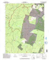
1995 Map of Sinks of Gandy
USGS Topo · Published 1998About this map
Monongahela National Forest dominates this highland landscape, where the high-altitude hydrology of the Allegheny Mountains defines the local geography. The map centers on the remarkable Sinks of Gandy, a limestone cavern system where Gandy Creek disappears underground, emerging south of the small settlement at Osceola. This karst topography is further evidenced by the nearby Blister Swamp, a unique wetland habitat situated among the peaks of Beech Mountain and Shavers Mountain.
Find a feature on this map
60 named features on this map. Tap any name to fly to it.
Don’t see what you’re looking for? This feature index may not catch every label — zoom into the map to look around manually.
Map Details
Editions of this 1995 Sinks of Gandy Map
This is the sole edition of this map. No revisions or reprints were ever made.
Other maps of this area

1889 · Beverly
USGS Topo · 1:125,000

1892 · Beverly
USGS Topo · 1:125,000

1909 · Elkins
USGS Topo · 1:62,500

1922 · Horton
USGS Topo · 1:48,000

1922 · Spruce Knob
USGS Topo · 1:48,000

1922 · Durbin
USGS Topo · 1:48,000

1924 · Durbin
USGS Topo · 1:62,500

1924 · Horton
USGS Topo · 1:62,500

1924 · Spruce Knob
USGS Topo · 1:62,500

1949 · Charlottesville
USGS Topo · 1:250,000