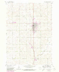
1964 Map of Sioux Center
USGS Topo · Published 1980About this map
Sioux Center serves as the primary hub of activity in this 1964 Iowa survey, which highlights the town's expansion near the Burlington Northern railroad. The inclusion of Dordt College and the Kinsey Sch reflects the community's mid-century development and focus on local education. Land use patterns are clearly delineated, with the grid of the city contrasting against the surrounding agricultural townships of Plato, Welcome, Center, and West Branch. Water features dominate the rural landscape, specifically the Sixmile Creek to the northwest and the West Branch Floyd River which meanders through the southern half of the quadrangle to join the Floyd River. Purple photorevisions from 1980 show suburban growth and institutional changes that occurred in the decade following the original field check.
Find a feature on this map
14 named features on this map. Tap any name to fly to it.
Don’t see what you’re looking for? This feature index may not catch every label — zoom into the map to look around manually.
Map Details
Editions of this 1964 Sioux Center Map
2 editions found
Other maps of this area

1955 · Sioux City
USGS Topo · 1:250,000

1955 · Sioux Falls
USGS Topo · 1:250,000

1958 · Sioux City
USGS Topo · 1:250,000

1958 · Sioux Falls
USGS Topo · 1:250,000

1959 · Sioux City
USGS Topo · 1:250,000

1962 · Le Mars
USGS Topo · 1:62,500

1964 · Orange City
USGS Topo · 1:24,000

1964 · Boyden
USGS Topo · 1:24,000

1964 · Sioux Center
USGS Topo · 1:24,000

1964 · Hull
USGS Topo · 1:24,000