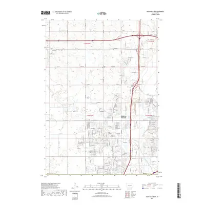
2017 Map of Sioux Falls West
USGS Topo · Published 2017About this map
Sioux Falls spreads across the eastern half of this landscape, showing the city's residential and educational expansion toward the west. The area around Southeast Technical Institute highlights the modern infrastructure of the region, where suburban streets meet the remaining agricultural sections of Minnehaha County. The winding path of Skunk Creek and the Big Sioux River define the local drainage and topography, creating natural breaks in the urban grid. To the west, the smaller settlement of Ellis remains distinct, bordered by Willow Creek. Local history and genealogy are anchored by established sites such as Bethel Cemetery and Forest Home Cemetery, which sit alongside historic section lines like Co Hwy 140 and W Benson Rd. The transition from city blocks to the open sections of t102n r50w illustrates the ongoing growth of South Dakota's largest metropolitan area.
Find a feature on this map
91 named features on this map. Tap any name to fly to it.
Don’t see what you’re looking for? This feature index may not catch every label — zoom into the map to look around manually.
Map Details
Editions of this 2017 Sioux Falls West Map
This is the sole edition of this map. No revisions or reprints were ever made.
Other maps of this area

1897 · Canton
USGS Topo · 1:125,000

1900 · Canton
USGS Topo · 1:125,000

1955 · Sioux Falls
USGS Topo · 1:250,000

1958 · Sioux Falls
USGS Topo · 1:250,000

1962 · Renner
USGS Topo · 1:24,000

1962 · Harrisburg
USGS Topo · 1:24,000

1962 · Sioux Falls East
USGS Topo · 1:24,000

1962 · Tea
USGS Topo · 1:24,000

1962 · Hartford South
USGS Topo · 1:24,000

1962 · Lennox NW
USGS Topo · 1:24,000