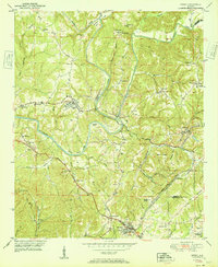
1951 Map of Sipsey
USGS Topo · Published 1951About this map
Sipsey and the surrounding coal-country landscape of the early 1950s are defined by the winding course of the Sipsey Fork Mulberry Fork. This era shows a region transition from rural homesteads to industrial mining centers, where clusters of homes at Sumiton and Empire sit adjacent to significant Strip Mine operations and a sprawling Mine Dump. The transportation network is anchored by the St Louis San Francisco railroad and the Bankhead Highway, which cut through the ridges of Walker County and Jefferson County. Local life is recorded through a dense network of family landmarks and community anchors like Rices Chapel, Akins Grove Ch, and the Wheeler Sch. The map also captures genealogical details in places like Drummond Cem and the small settlements of Cordell and Hull.
Find a feature on this map
67 named features on this map. Tap any name to fly to it.
Don’t see what you’re looking for? This feature index may not catch every label — zoom into the map to look around manually.
Map Details
Editions of this 1951 Sipsey Map
2 editions found
Other maps of this area

1889 · Birmingham
USGS Topo · 1:125,000

1892 · Birmingham
USGS Topo · 1:125,000

1893 · Jasper
USGS Topo · 1:125,000

1895 · Birmingham
USGS Topo · 1:125,000

1904 · Birmingham Coal District
USGS Topo · 1:62,500

1906 · Birmingham Special
USGS Topo · 1:62,500

1907 · Birmingham
USGS Topo · 1:125,000

1935 · Port Birmingham
USGS Topo · 1:48,000

1938 · Port Birmingham
USGS Topo · 1:62,500

1949 · Cordova
USGS Topo · 1:24,000