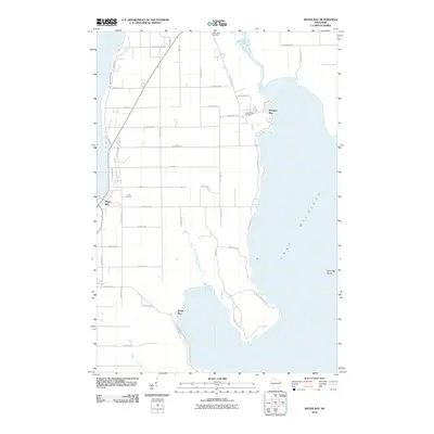
2010 Map of Sister Bay
USGS Topo · Published 2010About this map
Lake Michigan dominates the eastern and western horizons of this Door County peninsula survey, where the rugged shoreline is broken by sheltered inlets and narrow waterways. The village of Sister Bay sits on the western coast, serving as a primary hub for the region's road network, including the winding N Spring Rd and Old Stage Rd. To the east, the topography shifts toward the marshes of the Mink River and the small coastal settlement at Rowleys Bay.
Find a feature on this map
48 named features on this map. Tap any name to fly to it.
Don’t see what you’re looking for? This feature index may not catch every label — zoom into the map to look around manually.
Map Details
Editions of this 2010 Sister Bay Map
This is the sole edition of this map. No revisions or reprints were ever made.
Other maps of this area

1954 · Escanaba
USGS Topo · 1:250,000

1957 · Escanaba
USGS Topo · 1:250,000

1958 · Escanaba
USGS Topo · 1:250,000

1960 · Washington Island
USGS Topo · 1:62,500

1960 · Sister Bay
USGS Topo · 1:62,500

1960 · Ellison Bay
USGS Topo · 1:62,500

1981 · Marinette
USGS Topo · 1:100,000
1982 · Baileys Harbor West
USGS Topo · 1:24,000
1982 · Ellison Bay
USGS Topo · 1:24,000
1982 · Baileys Harbor East
USGS Topo · 1:24,000