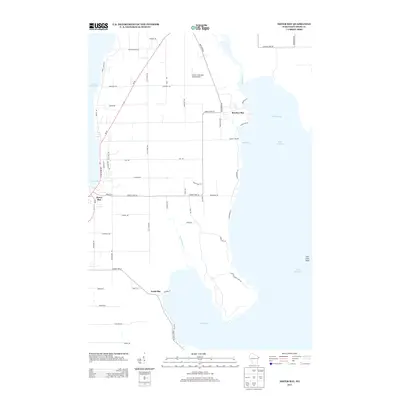
2013 Map of Sister Bay
USGS Topo · Published 2013About this map
Sister Bay and the surrounding Door County peninsula coastline define this topographic study, where the waters of Lake Michigan meet a network of rural roads and bays. The landscape is shaped by prominent coastal indentations including Rowleys Bay and North Bay, with the protected waters of Sand Bay tucked between them. Inland, the terrain is traversed by historical corridors such as Old Stage Rd and Hanson Dr, reflecting the area's agricultural and maritime heritage. The Mink River flows into the northern reaches of the peninsula, while Three Springs Cr drains toward the south, illustrating the intricate drainage patterns of this coastal shelf. A notable aviation landmark, Mave's Lakeview Road Airport, sits positioned between the main highway and the shoreline, serving as a distinct waypoint in the rural landscape.
Find a feature on this map
59 named features on this map. Tap any name to fly to it.
Don’t see what you’re looking for? This feature index may not catch every label — zoom into the map to look around manually.
Map Details
Editions of this 2013 Sister Bay Map
This is the sole edition of this map. No revisions or reprints were ever made.
Other maps of this area

1954 · Escanaba
USGS Topo · 1:250,000

1957 · Escanaba
USGS Topo · 1:250,000

1958 · Escanaba
USGS Topo · 1:250,000

1960 · Washington Island
USGS Topo · 1:62,500

1960 · Sister Bay
USGS Topo · 1:62,500

1960 · Ellison Bay
USGS Topo · 1:62,500

1981 · Marinette
USGS Topo · 1:100,000
1982 · Baileys Harbor West
USGS Topo · 1:24,000
1982 · Ellison Bay
USGS Topo · 1:24,000
1982 · Baileys Harbor East
USGS Topo · 1:24,000