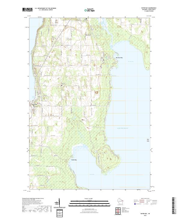
2022 Map of Sister Bay
USGS Topo · Published 2022About this map
Sister Bay and the northeastern shoreline of the Door Peninsula are documented here in detail, showcasing a landscape defined by its proximity to Lake Michigan. The settlement at Sister Bay is supported by local religious and community landmarks such as the Saint Rosalia Cem and the Sister Bay Moravian Cem, while the eastern coast at Rowleys Bay offers a more secluded character where the Mink River meets the lake. Inland, the terrain is marked by small water bodies like Zoo Lake and a grid of rural roads including Old Stage Rd and Co Rd Z. This map provides a clear record of modern property and transport patterns, from the recreational Water Trail to the residential clusters along Beach Rd and Meadow Wood Ln. The presence of the Rowleys Bay Cem and Four Foot Shoal illustrates the long-standing relationship between the peninsula's residents and the surrounding water.
Find a feature on this map
84 named features on this map. Tap any name to fly to it.
Don’t see what you’re looking for? This feature index may not catch every label — zoom into the map to look around manually.
Map Details
Editions of this 2022 Sister Bay Map
This is the sole edition of this map. No revisions or reprints were ever made.
Other maps of this area

1954 · Escanaba
USGS Topo · 1:250,000

1957 · Escanaba
USGS Topo · 1:250,000

1958 · Escanaba
USGS Topo · 1:250,000

1960 · Washington Island
USGS Topo · 1:62,500

1960 · Sister Bay
USGS Topo · 1:62,500

1960 · Ellison Bay
USGS Topo · 1:62,500

1981 · Marinette
USGS Topo · 1:100,000
1982 · Baileys Harbor West
USGS Topo · 1:24,000
1982 · Ellison Bay
USGS Topo · 1:24,000
1982 · Baileys Harbor East
USGS Topo · 1:24,000