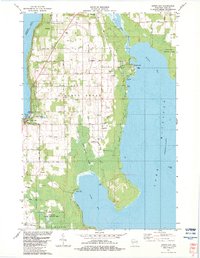
1982 Map of Sister Bay
USGS Topo · Published 1983About this map
Sister Bay and the surrounding township of Liberty Grove are documented here in the early 1980s, showcasing the transition of the northern Door Peninsula into a prominent recreational and conservation landscape. The coastal geography is defined by deep inlets and protected harbors like Rowleys Bay and North Bay, which remain largely undeveloped compared to the village center. This survey highlights the significant investment in public lands, with the expansive Newport State Park flanking Lake Michigan and the Mud Lake State Wildlife Area preserving inland wetlands. For the family historian, the map preserves the locations of local landmarks including the Ellison Bay Cem, Moravian Ch, and Zion Ch. The interior remains characterized by traditional land use, marked by numerous Gravel Pits, Quarries, and a network of rural routes such as Old Stage Road and Scandis Road.
Find a feature on this map
48 named features on this map. Tap any name to fly to it.
Don’t see what you’re looking for? This feature index may not catch every label — zoom into the map to look around manually.
Map Details
Editions of this 1982 Sister Bay Map
This is the sole edition of this map. No revisions or reprints were ever made.
Other maps of this area

1954 · Escanaba
USGS Topo · 1:250,000

1957 · Escanaba
USGS Topo · 1:250,000

1958 · Escanaba
USGS Topo · 1:250,000

1960 · Washington Island
USGS Topo · 1:62,500

1960 · Sister Bay
USGS Topo · 1:62,500

1960 · Ellison Bay
USGS Topo · 1:62,500

1981 · Marinette
USGS Topo · 1:100,000
1982 · Baileys Harbor West
USGS Topo · 1:24,000
1982 · Ellison Bay
USGS Topo · 1:24,000
1982 · Baileys Harbor East
USGS Topo · 1:24,000