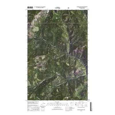
2017 Map of Sitdown Mountain
USGS Topo · Published 2017About this map
Colville National Forest dominates this section of Ferry County, where the topography is defined by a series of prominent peaks and drainage systems. The namesake Sitdown Mountain stands central to the quadrangle, flanked by Grizzly Mtn to the west and Bitterfoot Mtn to the south. A network of Forest Service and county roads, including White Mountain Rd and Co Hwy 99, provides access through the drainage basins of Hall Cr and Sitdown Cr. Notable water sources like Tanker Chance Spring and the aptly named Sleepy Hollow Cr illustrate the hydrological pattern of this high-elevation landscape. The map captures the organized layout of the Public Land Survey System, with township and range lines like t34n r35e dividing the forested terrain into a clear grid for land management and resource protection.
Find a feature on this map
35 named features on this map. Tap any name to fly to it.
Don’t see what you’re looking for? This feature index may not catch every label — zoom into the map to look around manually.
Map Details
Editions of this 2017 Sitdown Mountain Map
This is the sole edition of this map. No revisions or reprints were ever made.
Other maps of this area

1904 · Republic
USGS Topo · 1:125,000

1936 · Marcus
USGS Topo · 1:96,000

1942 · Marcus
USGS Topo · 1:125,000

1948 · Republic
USGS Topo · 1:62,500

1948 · Sherman Peak
USGS Topo · 1:62,500

1951 · Sherman Peak
USGS Topo · 1:62,500

1951 · Republic
USGS Topo · 1:62,500

1952 · Twin Lakes
USGS Topo · 1:62,500

1953 · Seventeenmile Mtn.
USGS Topo · 1:62,500

1954 · Okanogan
USGS Topo · 1:250,000