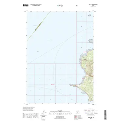
2017 Map of Sitka A-1 SE
USGS Topo · Published 2017About this map
Kupreanof Island dominates the eastern margin of this coastal survey, where the dense timber of the Tongass National Forest meets the waters of the Alexander Archipelago. This maritime landscape is defined by its deep water access and strategic coastal landmarks, including the prominent Point Macartney which juts into the junction of Frederick Sound and the Keku Strait. The terrain rises sharply from the shoreline toward interior heights like Bahovec Peak, reflecting the dramatic vertical relief typical of the region's glacial geography. To the north and west, the map transitions into the open Pacific Ocean, marked by maritime hazards such as West Pinta Rocks and the exposed headland of Cape Bendel. The boundary between the Hoonah-Angoon and Prince of Wales-Hyder Census Areas cuts across the sound, indicating the administrative divisions of these remote southeast Alaska waters.
Find a feature on this map
15 named features on this map. Tap any name to fly to it.
Don’t see what you’re looking for? This feature index may not catch every label — zoom into the map to look around manually.
Map Details
Editions of this 2017 Sitka A-1 SE Map
This is the sole edition of this map. No revisions or reprints were ever made.
Other maps of this area

1948 · Sumdum A-6
USGS Topo · 1:63,360

1948 · Petersburg D-6
USGS Topo · 1:63,360

1948 · Port Alexander D-1
USGS Topo · 1:63,360

1948 · Sitka A-1
USGS Topo · 1:63,360

1951 · Sitka
USGS Topo · 1:250,000

1951 · Port Alexander
USGS Topo · 1:250,000

1951 · Petersburg D-6
USGS Topo · 1:63,360

1952 · Petersburg
USGS Topo · 1:250,000

1952 · Port Alexander
USGS Topo · 1:250,000

1952 · Sumdum
USGS Topo · 1:250,000