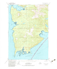
1951 Map of Sitka A-2
USGS Topo · Published 1983About this map
Admiralty Island National Monument and the surrounding reaches of the Tongass National Forest dominate this coastal landscape as it was documented in the mid-20th century. The intricate shoreline of the Admiralty Island coast is punctuated by a series of deep inlets and protected anchorages, including Whitewater Bay and the jagged fingers of Surprise Harbor. While much of the interior is defined by steep terrain like Table Mountain and Mt Safftan, the coastal fringes reveal small pockets of human activity. The settlement at Tyee and the isolated Pumphouse near the southern coast suggest the localized industrial or maritime operations of the era. This chart integrates hydrographic data from the U.S. Coast and Geodetic Survey to detail treacherous maritime features such as North Rock and the reefs of Murder Cove.
Find a feature on this map
33 named features on this map. Tap any name to fly to it.
Don’t see what you’re looking for? This feature index may not catch every label — zoom into the map to look around manually.
Map Details
Editions of this 1951 Sitka A-2 Map
3 editions found

Other maps of this area

1948 · Sitka B-3
USGS Topo · 1:63,360

1948 · Sitka B-1
USGS Topo · 1:63,360

1948 · Sitka A-3
USGS Topo · 1:63,360

1948 · Sitka A-2
USGS Topo · 1:63,360

1948 · Sitka B-2
USGS Topo · 1:63,360

1948 · Port Alexander D-1
USGS Topo · 1:63,360

1948 · Sitka A-1
USGS Topo · 1:63,360

1951 · Sitka
USGS Topo · 1:250,000

1951 · Port Alexander D-3
USGS Topo · 1:63,360

1951 · Port Alexander
USGS Topo · 1:250,000