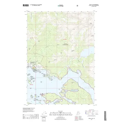
2017 Map of Sitka A-4 SW
USGS Topo · Published 2017About this map
Sitka occupies the coastal edge of Baranof Island in this 2017 survey, where the urban grid of Lincoln Street and Baranof Street meets the wilderness of the Tongass National Forest. This modern record preserves the layout of the Sitka National Cemetery and the protected grounds of Sitka National Historical Park at the mouth of the Indian River. The coastline is a dense network of named landmarks, from the sheltered waters of Sawmill Cove and Jamestown Bay to the numerous small landforms of the Eastern Channel like Kutkan Island and Harris Island. Inland, the terrain rises sharply into the peaks of the Coast Mountains, including Mt Verstovia and Gavan Hill. The map traces vital infrastructure and recreation paths, including the Indian River Road and the Herring Cove Trail, documenting the transition from the settlement's harbor to the high country of Billy Basin and The Sisters.
Find a feature on this map
72 named features on this map. Tap any name to fly to it.
Don’t see what you’re looking for? This feature index may not catch every label — zoom into the map to look around manually.
Map Details
Editions of this 2017 Sitka A-4 SW Map
This is the sole edition of this map. No revisions or reprints were ever made.
Other maps of this area

1948 · Sitka A-5
USGS Topo · 1:63,360

1951 · Port Alexander D-5
USGS Topo · 1:63,360

1951 · Sitka
USGS Topo · 1:250,000

1951 · Port Alexander D-4
USGS Topo · 1:63,360

1951 · Port Alexander
USGS Topo · 1:250,000

1951 · Sitka A-4
USGS Topo · 1:63,360

1951 · Sitka A-5
USGS Topo · 1:63,360

1952 · Port Alexander
USGS Topo · 1:250,000

1952 · Sitka
USGS Topo · 1:250,000

1954 · Sitka A-4
USGS Topo · 1:63,360