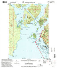
1996 Map of Sitka A-5
USGS Topo · Published 1999About this map
Baranof Island and the intricate archipelago surrounding Sitka Sound are captured here in a series of mid-1990s revisions that reflect a landscape of deep historical layers and maritime utility. The map details the transition from military and industrial use to conservation, marking the Army Camp (Ruins) near Shoals Point and a Log Transportation Facility on Kruzof Island alongside established protected areas like Old Sitka State Historic Park and the Magoun Islands State Marine Park. Maritime navigation remains central to the area's identity, evidenced by the Vitskari Island Light and numerous charted hazards like The Eckholms and Zenobia Rock. Land use is equally diverse, showing the winding Halibut Point Road leading toward a Rifle Range and a Landfill, while the interior remains defined by the Tongass National Forest and the prominent volcanic profile of Mount Edgecumbe.
Find a feature on this map
121 named features on this map. Tap any name to fly to it.
Don’t see what you’re looking for? This feature index may not catch every label — zoom into the map to look around manually.
Map Details
Editions of this 1996 Sitka A-5 Map
This is the sole edition of this map. No revisions or reprints were ever made.
Other maps of this area

1948 · Sitka A-5
USGS Topo · 1:63,360

1948 · Sitka B-5
USGS Topo · 1:63,360

1951 · Sitka B-4
USGS Topo · 1:63,360

1951 · Sitka A-6
USGS Topo · 1:63,360

1951 · Sitka B-6
USGS Topo · 1:63,360

1951 · Sitka B-5
USGS Topo · 1:63,360

1951 · Port Alexander D-5
USGS Topo · 1:63,360

1951 · Sitka
USGS Topo · 1:250,000

1951 · Port Alexander D-4
USGS Topo · 1:63,360

1951 · Port Alexander
USGS Topo · 1:250,000