
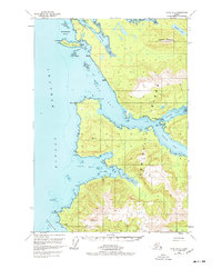
1951 Map of Sitka B-2
USGS Topo · Published 1972About this map
Angoon and the nearby settlement of Killisnoo anchor the western edge of Admiralty Island in this mid-century coastal survey. Facing the deep waters of Chatham Strait, the map documents a maritime landscape where travel and industry follow the intricate shoreline. Early mineral interests are visible at the head of Kanalku Bay, where a Coal Mine and several Coal Claims are noted near the base of Kanalku Mountain. The intricate waterway of Kootznahoo Roads and the shelter of Killisnoo Harbor highlight the area's importance for local navigation. To the south, the village of Neltushkin sits on the northern reaches of Whitewater Bay, while the bifurcated Hood Bay reaches deep into the interior with its North Arm and South Arm. This survey captures the traditional Tlingit lands within the Tongass National Forest before later modern developments.
Find a feature on this map
36 named features on this map. Tap any name to fly to it.
Don’t see what you’re looking for? This feature index may not catch every label — zoom into the map to look around manually.
Map Details
Editions of this 1951 Sitka B-2 Map
2 editions found
Other maps of this area

1948 · Sitka B-3
USGS Topo · 1:63,360

1948 · Sitka B-1
USGS Topo · 1:63,360

1948 · Sitka A-3
USGS Topo · 1:63,360

1948 · Sitka C-2
USGS Topo · 1:63,360

1948 · Sitka A-2
USGS Topo · 1:63,360

1948 · Sitka C-3
USGS Topo · 1:63,360

1948 · Sitka C-1
USGS Topo · 1:63,360

1948 · Sitka B-2
USGS Topo · 1:63,360

1948 · Sitka A-1
USGS Topo · 1:63,360

1951 · Sitka
USGS Topo · 1:250,000