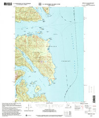
1997 Map of Sitka B-3
USGS Topo · Published 2000About this map
Chichagof Island, Catherine Island, and the northern edge of Baranof Island converge in this coastal survey within the Tongass National Forest. The map documents the intricate waterways and maritime navigation markers necessary for travel through the Alaska Marine Highway, including the Craven Light Lighthouse Reserve and an additional Lighthouse Reserve near Fairway Island. Evidence of human activity is sparse but notable, with Cabins tucked away on islands and Ruins located along the shoreline of Catherine Island, indicating seasonal or historical camps. The coastal morphology is defined by narrow passages like Thatcher Channel and the expansive waters of Kelp Bay, where several arms reach deep into the forested interior. This 1997 revision provides a record of these remote coastal lands before the turn of the millennium.
Find a feature on this map
48 named features on this map. Tap any name to fly to it.
Don’t see what you’re looking for? This feature index may not catch every label — zoom into the map to look around manually.
Map Details
Editions of this 1997 Sitka B-3 Map
This is the sole edition of this map. No revisions or reprints were ever made.
Other maps of this area

1948 · Sitka B-3
USGS Topo · 1:63,360

1948 · Sitka A-3
USGS Topo · 1:63,360

1948 · Sitka C-2
USGS Topo · 1:63,360

1948 · Sitka A-2
USGS Topo · 1:63,360

1948 · Sitka C-3
USGS Topo · 1:63,360

1948 · Sitka B-2
USGS Topo · 1:63,360

1951 · Sitka B-4
USGS Topo · 1:63,360

1951 · Sitka C-4
USGS Topo · 1:63,360

1951 · Sitka
USGS Topo · 1:250,000

1951 · Sitka A-4
USGS Topo · 1:63,360