
1951 Map of Sitka C-4
USGS Topo · Published 1956About this map
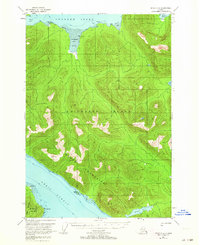
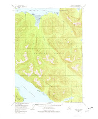
Chichagof Island and the jagged Moore Mountains dominate this mid-century cartographic study of the Alexander Archipelago. Mapping reveals a landscape defined by deep fjords and maritime pathways, specifically the broad Tenakee Inlet to the north and Peril Strait to the south, which separates the land from Baranof Island. The presence of small scattered cabins along the shoreline, particularly near Kadashan Bay and its extensive tidal flat, suggests a seasonal or subsistence-based human presence within the Tongass National Forest during the late 1940s and early 1950s.
Find a feature on this map
18 named features on this map. Tap any name to fly to it.
Don’t see what you’re looking for? This feature index may not catch every label — zoom into the map to look around manually.
Map Details
Editions of this 1951 Sitka C-4 Map
3 editions found
Other maps of this area

1948 · Sitka B-3
USGS Topo · 1:63,360

1948 · Sitka C-3
USGS Topo · 1:63,360

1948 · Sitka D-5
USGS Topo · 1:63,360

1948 · Sitka D-3
USGS Topo · 1:63,360

1948 · Sitka D-4
USGS Topo · 1:63,360

1948 · Sitka B-5
USGS Topo · 1:63,360

1951 · Sitka B-4
USGS Topo · 1:63,360

1951 · Sitka C-5
USGS Topo · 1:63,360

1951 · Sitka B-5
USGS Topo · 1:63,360

1951 · Sitka
USGS Topo · 1:250,000