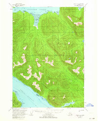
1951 Map of Sitka C-4
USGS Topo · Published 1964About this map
Chichagof Island dominates this mid-century survey, defined by the towering Moore Mountains and the intricate shoreline of the Tongass National Forest. The landscape is a complex network of waterways, from the deep Tenakee Inlet in the north to Peril Strait in the south, separating the island from Baranof Island. Coastal activity is marked by isolated cabins located near Kadashan Bay and Kook Lake, suggesting small-scale seasonal habitations or resource outposts in an era before widespread development. The presence of a tidal flat at the head of Kadashan Bay and several triangulation stations, such as VABM 2680 Moore, highlights the detailed hydrographic and geodetic work required to map this Alexander Archipelago terrain. The map also traces the Duffield Peninsula and named coastal points like Peschani Pt and Pt Elizabeth, which served as vital navigation markers for vessels moving through these narrow Alaskan channels.
Find a feature on this map
23 named features on this map. Tap any name to fly to it.
Don’t see what you’re looking for? This feature index may not catch every label — zoom into the map to look around manually.
Map Details
Editions of this 1951 Sitka C-4 Map
3 editions found
Other maps of this area

1948 · Sitka B-3
USGS Topo · 1:63,360

1948 · Sitka C-3
USGS Topo · 1:63,360

1948 · Sitka D-5
USGS Topo · 1:63,360

1948 · Sitka D-3
USGS Topo · 1:63,360

1948 · Sitka D-4
USGS Topo · 1:63,360

1948 · Sitka B-5
USGS Topo · 1:63,360

1951 · Sitka B-4
USGS Topo · 1:63,360

1951 · Sitka C-5
USGS Topo · 1:63,360

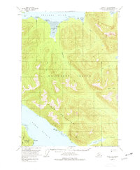
1951 · Sitka C-4
USGS Topo · 1:63,360

1951 · Sitka B-5
USGS Topo · 1:63,360