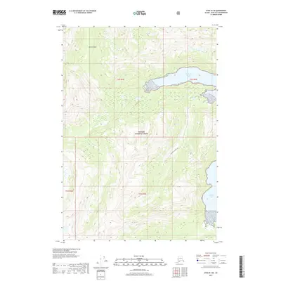
2017 Map of Sitka B-4 SE
USGS Topo · Published 2017About this map
Baranof Island terrain dominates this 2017 study of the Southeast Alaskan wilderness, where the high ridges and steep slopes of the Tongass National Forest meet the convoluted coastline of the Alexander Archipelago. The map focuses on the complex saltwater inlets of Kelp Bay, specifically Middle Arm Kelp Bay and South Arm Kelp Bay. This is a landscape defined by deep fjords and maritime drainages, where Bourbon Ck Middle Arm flows through the dense coastal forest. The lack of modern road infrastructure underscores the area's isolation and its reliance on the water for access. This USGS survey provides a precise look at the township and range lines, including t52s r65e, across a largely uninhabited and pristine maritime environment.
Find a feature on this map
9 named features on this map. Tap any name to fly to it.
Don’t see what you’re looking for? This feature index may not catch every label — zoom into the map to look around manually.
Map Details
Editions of this 2017 Sitka B-4 SE Map
This is the sole edition of this map. No revisions or reprints were ever made.
Other maps of this area

1948 · Sitka B-3
USGS Topo · 1:63,360

1948 · Sitka A-3
USGS Topo · 1:63,360

1951 · Sitka B-4
USGS Topo · 1:63,360

1951 · Sitka
USGS Topo · 1:250,000

1951 · Sitka A-4
USGS Topo · 1:63,360

1951 · Sitka B-3
USGS Topo · 1:63,360
1951 · Sitka A-3
USGS Topo · 1:63,360

1952 · Sitka
USGS Topo · 1:250,000

1954 · Sitka A-4
USGS Topo · 1:63,360

1964 · Sitka
USGS Topo · 1:250,000