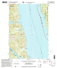
1997 Map of Sitka C-3
USGS Topo · Published 2000About this map
Chichagof Island and Admiralty Island face one another across the wide expanse of Chatham Strait in this late 20th-century survey. The map details the coastal infrastructure and wilderness management areas within the Tongass National Forest, including the Kootznoowoo Wilderness and the Trap Bay LUD II Management Area. Local transport and subsistence patterns are evident through features like the Alaska Marine Highway and the Sitkoh Lake Trail.
Find a feature on this map
30 named features on this map. Tap any name to fly to it.
Don’t see what you’re looking for? This feature index may not catch every label — zoom into the map to look around manually.
Map Details
Editions of this 1997 Sitka C-3 Map
This is the sole edition of this map. No revisions or reprints were ever made.
Other maps of this area

1948 · Sitka B-3
USGS Topo · 1:63,360

1948 · Sitka C-2
USGS Topo · 1:63,360

1948 · Sitka C-3
USGS Topo · 1:63,360

1948 · Sitka D-3
USGS Topo · 1:63,360

1948 · Sitka D-2
USGS Topo · 1:63,360

1948 · Sitka D-4
USGS Topo · 1:63,360

1948 · Sitka B-2
USGS Topo · 1:63,360

1951 · Sitka B-4
USGS Topo · 1:63,360

1951 · Sitka C-4
USGS Topo · 1:63,360

1951 · Sitka
USGS Topo · 1:250,000