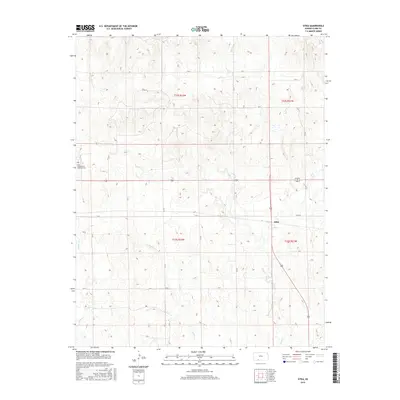
2015 Map of Sitka
USGS Topo · Published 2015About this map
Sitka serves as the primary focal point of this southwestern Kansas landscape, situated near the intersection of several local routes. The terrain is defined by the winding paths of Day Cr and Spring Cr, which carve through the open plains and contribute to the area's agricultural character. Genealogists will find the Saint Josephs and Highland Cem in the northwestern quadrant, a significant site for tracing family histories in Clark County. The map provides a clear picture of the modern rural road network, including Sitka Rd and numerous county routes like CR 24 and CR U, which follow the rigid grid of the Public Land Survey System. This interplay between the natural drainage of the creeks and the rectilinear section lines illustrates the persistent influence of 19th-century land management on the contemporary landscape.
Find a feature on this map
22 named features on this map. Tap any name to fly to it.
Don’t see what you’re looking for? This feature index may not catch every label — zoom into the map to look around manually.
Map Details
Editions of this 2015 Sitka Map
This is the sole edition of this map. No revisions or reprints were ever made.
Other maps of this area

1894 · Sitka
USGS Topo · 1:62,500

1896 · Ashland
USGS Topo · 1:125,000

1955 · Pratt
USGS Topo · 1:250,000

1959 · Pratt
USGS Topo · 1:250,000
1972 · Ashland SE
USGS Topo · 1:24,000
1972 · Ashland
USGS Topo · 1:24,000

1979 · Sitka
USGS Topo · 1:24,000

1979 · Bloom SE
USGS Topo · 1:24,000

1979 · Sugarloaf
USGS Topo · 1:24,000
1979 · Sitka SW
USGS Topo · 1:24,000