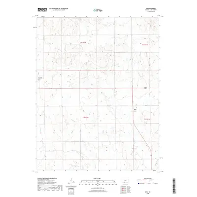
2018 Map of Sitka
USGS Topo · Published 2018About this map
Sitka serves as the focal point of this Clark County landscape, situated where the high plains begin to break into the drainage systems of the Cimarron River basin. The area is defined by a grid of county roads that navigate the subtle topography, with Sitka Rd and CR U providing primary access to the surrounding farmsteads and rangelands. Water management and natural drainage are evident through the paths of Spring Cr and Day Cr, which meander through the township divisions of t33s r22w and t33s r21w. A significant site for local genealogy is the Saint Joseph's and Highland Cem, located in the northwestern portion of the map. This site remains a primary landmark for tracing the early Catholic and settler history of the region, anchored by the church and cemetery grounds that have served the community for generations.
Find a feature on this map
23 named features on this map. Tap any name to fly to it.
Don’t see what you’re looking for? This feature index may not catch every label — zoom into the map to look around manually.
Map Details
Editions of this 2018 Sitka Map
This is the sole edition of this map. No revisions or reprints were ever made.
Other maps of this area

1894 · Sitka
USGS Topo · 1:62,500

1896 · Ashland
USGS Topo · 1:125,000

1955 · Pratt
USGS Topo · 1:250,000

1959 · Pratt
USGS Topo · 1:250,000
1972 · Ashland SE
USGS Topo · 1:24,000
1972 · Ashland
USGS Topo · 1:24,000

1979 · Sitka
USGS Topo · 1:24,000

1979 · Bloom SE
USGS Topo · 1:24,000

1979 · Sugarloaf
USGS Topo · 1:24,000
1979 · Sitka SW
USGS Topo · 1:24,000