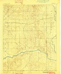
1894 Map of Sitka
USGS Topo · Published 1902About this map
The Atchison Topeka and Santa Fe R.R. cuts a precise line across this plains landscape, marking the vital transportation corridor that sustained the small settlement of Sitka. Surveyed in the early 1890s, the map reveals a region defined by its drainage systems, where the meandering Cimarron River flows through the southern reaches. Numerous seasonal and perennial waterways like Snake Creek, Day Creek, and Spring Creek carve into the terrain, illustrating the natural water sources that dictated early settlement patterns and ranching boundaries in this corner of Clark County and Comanche County. The inclusion of the Kansas Oklahoma Boundary Line at the southern edge emphasizes the map's location at a significant geopolitical border during the transition from the territorial era toward statehood.
Find a feature on this map
16 named features on this map. Tap any name to fly to it.
Don’t see what you’re looking for? This feature index may not catch every label — zoom into the map to look around manually.
Map Details
Editions of this 1894 Sitka Map
2 editions found
Other maps of this area

1892 · Coldwater
USGS Topo · 1:125,000

1894 · Sitka
USGS Topo · 1:62,500

1896 · Ashland
USGS Topo · 1:125,000

1955 · Woodward
USGS Topo · 1:250,000

1955 · Pratt
USGS Topo · 1:250,000

1958 · Woodward
USGS Topo · 1:250,000

1959 · Pratt
USGS Topo · 1:250,000

1970 · Selman NW
USGS Topo · 1:24,000

1970 · Buffalo NW
USGS Topo · 1:24,000

1970 · Rosston NE
USGS Topo · 1:24,000