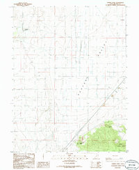
1986 Map of Sixmile Point
USGS Topo · Published 1986About this map
Pahvant Valley dominates this 1986 topographical study of the arid interior of Millard County, Utah. The landscape is defined by the sharp contrast between the flat valley floor, crisscrossed by an extensive irrigation network of ditches and scattered wells, and the abrupt rising of Beaver Ridge to the west and the foothills of the Fishlake National Forest to the southeast. Historically significant landmarks such as Telegraph Point and the thermal waters at Hot Springs punctuate the northern reaches of the quadrangle. Human activity in this desert environment is sparse, centered on resource extraction at the Gravel Pit and the maintenance of transport routes through the valley, including a modern Rest Area and roads tracking alongside the Dry Wash. The map preserves the exact placement of prominent geographic markers like Sixmile Point and Eightmile Point as they stood in the mid-1980s.
Find a feature on this map
14 named features on this map. Tap any name to fly to it.
Don’t see what you’re looking for? This feature index may not catch every label — zoom into the map to look around manually.
Map Details
Editions of this 1986 Sixmile Point Map
This is the sole edition of this map. No revisions or reprints were ever made.
Other maps of this area

1885 · Beaver
USGS Topo · 1:250,000

1932 · Sevier
USGS Topo · 1:62,500

1935 · Sevier
USGS Topo · 1:62,500

1953 · Richfield
USGS Topo · 1:250,000

1958 · Richfield
USGS Topo · 1:250,000

1960 · Meadow
USGS Topo · 1:24,000

1962 · Fillmore
USGS Topo · 1:62,500

1962 · Tabernacle Hill
USGS Topo · 1:62,500

1962 · Cove Fort
USGS Topo · 1:62,500

1980 · Richfield
USGS Topo · 1:100,000