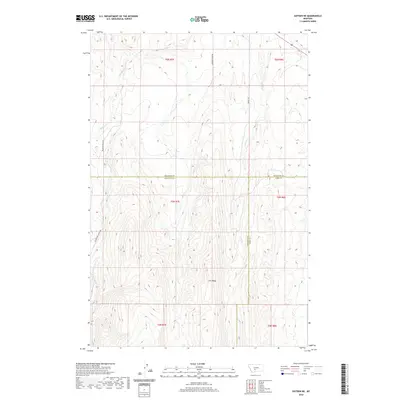
2020 Map of Sixteen NE
USGS Topo · Published 2020About this map
The Middle Fork Sixteenmile Cr cuts through the southwest corner of this high-altitude landscape, where the borders of Gallatin, Meagher, and Park counties converge. Centered on the prominent Elk Ridge, the terrain is defined by a series of north-south drainage systems including Meadow Cr, Lost Cr, and Potter Cr. This modern survey illustrates the remote character of this Montana ranching and wilderness area, where movement is dictated by the rugged topography and a sparse network of mountain roads such as Meadow Creek Rd and Sixteen Mile Creek Rd. The map serves as a detailed record of the Public Land Survey System divisions across Townships 4, 5, and 6 North, revealing how historical section lines continue to structure land ownership and management in the modern era.
Find a feature on this map
17 named features on this map. Tap any name to fly to it.
Don’t see what you’re looking for? This feature index may not catch every label — zoom into the map to look around manually.
Map Details
Editions of this 2020 Sixteen NE Map
This is the sole edition of this map. No revisions or reprints were ever made.
Other maps of this area

1886 · Little Belt Mts.
USGS Topo · 1:250,000

1894 · Little Belt Mts.
USGS Topo · 1:250,000

1897 · Little Belt Mts.
USGS Topo · 1:250,000

1898 · Little Belt Mts.
USGS Topo · 1:250,000

1902 · Little Belt Mts.
USGS Topo · 1:250,000

1948 · White Sulphur Springs
USGS Topo · 1:250,000

1948 · Sixteen
USGS Topo · 1:24,000

1951 · Sixteen NE
USGS Topo · 1:24,000
1951 · Wallrock
USGS Topo · 1:24,000

1951 · Hamen
USGS Topo · 1:24,000