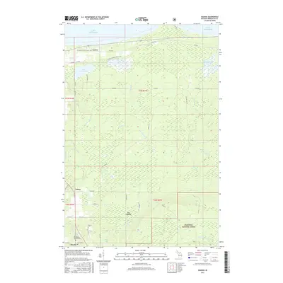
2017 Map of Skandia
USGS Topo · Published 2017About this map
The southern shoreline of Lake Superior dominates this portion of Marquette County, where the transition from coastal waters to the dense interior of the Hiawatha National Forest is defined by a complex network of wetlands and drainage basins. Small settlements like Yalmar and New Dalton are situated along a grid of local roads including Yalmer Rd and Dalton Rd, reflecting the rural character of West Branch Township in the early 21st century. The landscape is heavily marked by water, from the expansive Lake Kawbawgam and Lake LeVasseur to the managed waters of James Jeske Flooding. For genealogists and local historians, the area near the southwestern corner contains key landmarks such as the Haglund Cem and the United Methodist Church Cem. The N Country National Scenic Trail winds through the northern sections, following the terrain between the lakefront and the many branches of the Sand River.
Find a feature on this map
42 named features on this map. Tap any name to fly to it.
Don’t see what you’re looking for? This feature index may not catch every label — zoom into the map to look around manually.
Map Details
Editions of this 2017 Skandia Map
This is the sole edition of this map. No revisions or reprints were ever made.
Other maps of this area

1907 · Marquette
USGS Topo · 1:62,500

1932 · Skandia SW
USGS Topo · 1:31,680

1932 · Skandia SE
USGS Topo · 1:31,680

1932 · Skandia NE
USGS Topo · 1:31,680

1932 · Harvey SE
USGS Topo · 1:31,680

1932 · Harvey NE
USGS Topo · 1:31,680

1950 · Skandia NW
USGS Topo · 1:31,680

1952 · Gwinn
USGS Topo · 1:62,500

1954 · Marquette
USGS Topo · 1:62,500

1958 · Laughing Fish Point
USGS Topo · 1:62,500