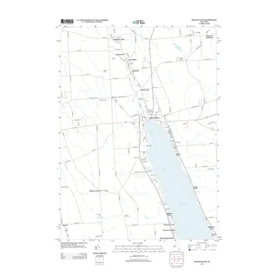
2013 Map of Skaneateles
USGS Topo · Published 2013About this map
Skaneateles Lake serves as the focal point for this Finger Lakes region survey, where the village of Skaneateles sits at the northern tip. The landscape transition from the lake's steep eastern shores to the northern milling settlements is clearly visible, with the Skaneateles Creek corridor supporting communities like Willow Glen, Mottville, and Skaneateles Falls. For genealogists and local researchers, the map provides precise locations for numerous burial sites including Mottville Cem, Saint Marys Cem, and Lakeview Cem. The northern rural reaches feature family-named locales like Shepard Settlement and Wicks Corners, while the western edge is marked by smaller farming hamlets at Baptist Corners and Degroff. The map also captures specialized land use along the shoreline, from Sandy Beach to the aviation footprint of the Skaneateles Aero Drome.
Find a feature on this map
136 named features on this map. Tap any name to fly to it.
Don’t see what you’re looking for? This feature index may not catch every label — zoom into the map to look around manually.
Map Details
Editions of this 2013 Skaneateles Map
This is the sole edition of this map. No revisions or reprints were ever made.
Other maps of this area

1899 · Auburn
USGS Topo · 1:62,500

1899 · Skaneateles
USGS Topo · 1:62,500

1900 · Baldwinsville
USGS Topo · 1:62,500

1902 · Skaneateles
USGS Topo · 1:62,500

1902 · Weedsport
USGS Topo · 1:62,500

1902 · Auburn
USGS Topo · 1:62,500

1943 · Jordan
USGS Topo · 1:31,680

1943 · Spafford
USGS Topo · 1:31,680

1943 · Owasco
USGS Topo · 1:31,680
1943 · Scipio
USGS Topo · 1:31,680