
1954 Map of Skanee
USGS Topo · Published 1956About this map
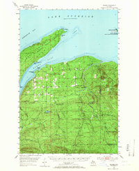
Skanee and the surrounding wilderness of the Baraga State Forest are documented here in the mid-1950s, showing a landscape defined by the timber industry and Lake Superior's rugged shoreline. The settlement itself is centered near Huron Bay, supported by the Swedish Ch, Skanee Sch, and Skanee Cem. Logging's footprint is evident in the numerous remote camps scattered through the interior, including Girard Camp, Erickson Camp, and Eliason Camp.
Find a feature on this map
54 named features on this map. Tap any name to fly to it.
Don’t see what you’re looking for? This feature index may not catch every label — zoom into the map to look around manually.
Map Details
Editions of this 1954 Skanee Map
2 editions found
Other maps of this area

1954 · Traverse Island
USGS Topo · 1:24,000

1954 · Huron Mountain
USGS Topo · 1:62,500

1954 · Keweenaw Bay
USGS Topo · 1:62,500

1955 · Herman
USGS Topo · 1:62,500

1955 · Champion
USGS Topo · 1:62,500

1956 · Michigamme
USGS Topo · 1:62,500

1958 · Hancock
USGS Topo · 1:250,000

1958 · Marquette
USGS Topo · 1:250,000

1958 · Iron River
USGS Topo · 1:250,000

1960 · Iron River
USGS Topo · 1:250,000