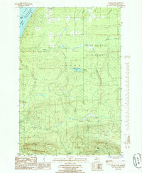
1985 Map of Skanee South
USGS Topo · Published 1985About this map
Mount Arvon, Michigan's highest natural point, anchors the rugged interior of this 1980s survey. Located within the Copper Country State Forest, the landscape is defined by the sharp descent from the highlands of L'Anse and Arvon toward the shores of Lake Superior. The northern coastline is marked by Huron Bay and the projection of Bendry Point, where the small settlement of Skanee provides a gateway to the wilderness.
Find a feature on this map
21 named features on this map. Tap any name to fly to it.
Don’t see what you’re looking for? This feature index may not catch every label — zoom into the map to look around manually.
Map Details
Editions of this 1985 Skanee South Map
This is the sole edition of this map. No revisions or reprints were ever made.
Other maps of this area

1954 · Skanee
USGS Topo · 1:62,500

1954 · Keweenaw Bay
USGS Topo · 1:62,500

1955 · Herman
USGS Topo · 1:62,500

1956 · Michigamme
USGS Topo · 1:62,500

1958 · Iron River
USGS Topo · 1:250,000

1960 · Iron River
USGS Topo · 1:250,000

1961 · Iron River
USGS Topo · 1:250,000

1967 · Iron River
USGS Topo · 1:250,000
1984 · Glovers Corner
USGS Topo · 1:24,000
1984 · McComb Corner
USGS Topo · 1:24,000