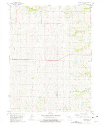
1981 Map of Skidmore NW
USGS Topo · Published 1982About this map
Little Tarkio Creek and its winding tributaries, including the East Fork Little Tarkio Creek and Headrick Branch, define the agricultural character of this northwestern Missouri landscape. The map captures a largely rural section of Colfax and Lincoln townships at the start of the 1980s, where the drainage patterns of small waterways like Hull Cr and Long Branch dictate the placement of local roads and farmsteads.
Find a feature on this map
13 named features on this map. Tap any name to fly to it.
Don’t see what you’re looking for? This feature index may not catch every label — zoom into the map to look around manually.
Map Details
Editions of this 1981 Skidmore NW Map
This is the sole edition of this map. No revisions or reprints were ever made.
Other maps of this area

1939 · Tarkio
USGS Topo · 1:62,500

1939 · Farragut
USGS Topo · 1:62,500

1939 · Skidmore
USGS Topo · 1:62,500

1940 · Tarkio
USGS Topo · 1:62,500

1940 · Farragut
USGS Topo · 1:62,500

1940 · Coin
USGS Topo · 1:62,500

1941 · Tarkio
USGS Topo · 1:62,500

1941 · Skidmore
USGS Topo · 1:62,500

1942 · Skidmore
USGS Topo · 1:62,500

1943 · Coin
USGS Topo · 1:62,500