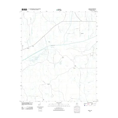
2012 Map of Skuna
USGS Topo · Published 2012About this map
The Skuna River and the engineered Skuna River Canal dominate this portion of Calhoun County, illustrating a landscape defined by significant water management and drainage efforts. The map reveals a rural settlement pattern where small communities like Shepherd, Bounds, Pittman, and Partee are linked by an extensive network of county roads. For genealogists and local historians, the sheet is particularly valuable for its documentation of several burial sites, including Zion Springs Cem, Mount Tabor Cem, and Old Tabernacle Cem, which serve as anchors for the area's dispersed homesteads. The terrain is crisscrossed by numerous named waterways such as Lickup Cr, Burkes Cr, and Savannah Cr, reflecting a bottomland geography where timber and agriculture have long been shaped by the river's influence.
Find a feature on this map
52 named features on this map. Tap any name to fly to it.
Don’t see what you’re looking for? This feature index may not catch every label — zoom into the map to look around manually.
Map Details
Editions of this 2012 Skuna Map
This is the sole edition of this map. No revisions or reprints were ever made.
Other maps of this area

1953 · West Point
USGS Topo · 1:250,000

1954 · Pittsboro
USGS Topo · 1:62,500

1954 · Water Valley
USGS Topo · 1:62,500

1955 · Water Valley
USGS Topo · 1:62,500

1955 · Coffeeville
USGS Topo · 1:62,500

1956 · Tupelo
USGS Topo · 1:250,000

1958 · Tupelo
USGS Topo · 1:250,000

1958 · West Point
USGS Topo · 1:250,000

1963 · West Point
USGS Topo · 1:250,000
1972 · Banner
USGS Topo · 1:24,000