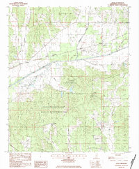
1983 Map of Skuna
USGS Topo · Published 1984About this map
Skuna Valley is defined by a landscape of drainage and reforestation in the early 1980s, where the engineered Skuna River Canal runs parallel to the meandering path of the original Skuna River. This area of Calhoun County is largely dominated by the Calhoun County State Wildlife Management Area, which covers a significant portion of the southern terrain. Historical human geography is preserved through the locations of rural congregations like Zion Springs Ch, Mt Tabor Ch, and Tabernacle Ch. Traces of the region's long-standing land divisions are visible in the Old Indian Treaty Boundary crossing the southwest corner, while small hamlets such as Pittman, Partee, and Shepherd mark the quiet intersections of country roads during this period.
Find a feature on this map
30 named features on this map. Tap any name to fly to it.
Don’t see what you’re looking for? This feature index may not catch every label — zoom into the map to look around manually.
Map Details
Editions of this 1983 Skuna Map
This is the sole edition of this map. No revisions or reprints were ever made.
Other maps of this area

1953 · West Point
USGS Topo · 1:250,000

1954 · Pittsboro
USGS Topo · 1:62,500

1954 · Water Valley
USGS Topo · 1:62,500

1955 · Water Valley
USGS Topo · 1:62,500

1955 · Coffeeville
USGS Topo · 1:62,500

1956 · Tupelo
USGS Topo · 1:250,000

1958 · Tupelo
USGS Topo · 1:250,000

1958 · West Point
USGS Topo · 1:250,000

1963 · West Point
USGS Topo · 1:250,000
1972 · Banner
USGS Topo · 1:24,000