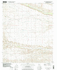
1996 Map of Skute Stone Arroyo
USGS Topo · Published 2002About this map
Las Animas Creek and the deep drainage of Percha Creek dominate this Sierra County landscape, where the high desert meets localized ranching and mining operations. The map provides a detailed look at the rural land use patterns of the mid-to-late 20th century, centering on isolated outposts like Coalson Ranch and Clark Ranch. These settlements are situated among a complex network of dry washes, including Greenhorn Arroyo and the eponymous Skute Stone Arroyo, which define the local topography.
Find a feature on this map
22 named features on this map. Tap any name to fly to it.
Don’t see what you’re looking for? This feature index may not catch every label — zoom into the map to look around manually.
Map Details
Editions of this 1996 Skute Stone Arroyo Map
This is the sole edition of this map. No revisions or reprints were ever made.
Other maps of this area

1935 · Hillsboro
USGS Topo · 1:48,000

1940 · Hillsboro
USGS Topo · 1:62,500

1954 · Tularosa
USGS Topo · 1:250,000

1955 · Las Cruces
USGS Topo · 1:250,000

1958 · Las Cruces
USGS Topo · 1:250,000

1958 · Tularosa
USGS Topo · 1:250,000

1961 · Skute Stone Arroyo
USGS Topo · 1:24,000

1961 · Saladone Tank
USGS Topo · 1:24,000

1961 · Caballo
USGS Topo · 1:24,000

1961 · Clark Spring Canyon
USGS Topo · 1:24,000