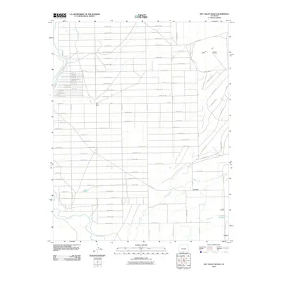
2010 Map of Sky Valley Ranch
USGS Topo · Published 2010About this map
Rio Grande waters define the western edge of this Costilla County landscape, where the high desert terrain meets a structured grid of agricultural roads and irrigation infrastructure. The settlement of Eastdale and the ranching hub of Sky Valley Ranch serve as focal points in an area shaped by the management of water, evidenced by the Jaroso Ditch, Garcia Tank, and the Anderson Reservoir to the southeast. To the northeast, the volcanic profile of Mesita Hill rises above the plain, hosting the Jake and Hank Mine. This 2010 survey illustrates the enduring intersection of historic land use and modern resource management, from the tiny community of Jaroso near the southern border to the Jaroso Cemetery, which provides a touchstone for local family history and genealogy. The naming conventions of local routes, such as Hovenweep Trl and Uncompagre Trl, reflect a synthesis of regional cultural influences within the San Luis Valley.
Find a feature on this map
78 named features on this map. Tap any name to fly to it.
Don’t see what you’re looking for? This feature index may not catch every label — zoom into the map to look around manually.
Map Details
Editions of this 2010 Sky Valley Ranch Map
This is the sole edition of this map. No revisions or reprints were ever made.
Other maps of this area

1954 · Raton
USGS Topo · 1:250,000

1954 · Trinidad
USGS Topo · 1:250,000

1955 · Trinidad
USGS Topo · 1:250,000

1958 · Raton
USGS Topo · 1:250,000

1958 · Trinidad
USGS Topo · 1:250,000

1959 · Trinidad
USGS Topo · 1:250,000

1963 · Costilla
USGS Topo · 1:24,000

1963 · Ute Mountain
USGS Topo · 1:24,000
1963 · La Segita Peaks NE
USGS Topo · 1:24,000

1967 · Manassa NE
USGS Topo · 1:24,000