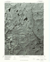
1976 Map of Skytop
USGS Topo · Published 1978About this map
Skytop and Canadensis anchor this orthophotomap, which presents a high-altitude aerial perspective of the Monroe County landscape during the mid-1970s. Produced through optical scanning of 1976 photography, the imagery reveals the dense forest cover and complex water systems of the Pocono region. The winding path of Bush Kill cuts through the eastern portion of the sheet, while the southwestern corner is defined by the course of Brodhead Creek. The map provides a unique visual record of land use and vegetation patterns before later decades of development, centered around Browns Lake. This specialized photographic survey, created in cooperation with the Soil Conservation Service, offers a distinct alternative to traditional line-and-symbol topographic maps by showing the literal ground cover of the era.
Find a feature on this map
5 named features on this map. Tap any name to fly to it.
Don’t see what you’re looking for? This feature index may not catch every label — zoom into the map to look around manually.
Map Details
Editions of this 1976 Skytop Map
This is the sole edition of this map. No revisions or reprints were ever made.
Other maps of this area

1919 · Pocono
USGS Topo · 1:62,500

1921 · Pocono
USGS Topo · 1:62,500

1923 · Pocono
USGS Topo · 1:62,500

1924 · Bushkill
USGS Topo · 1:48,000

1928 · Ariel
USGS Topo · 1:62,500

1932 · Ariel
USGS Topo · 1:62,500

1935 · Hawley
USGS Topo · 1:62,500

1938 · Hawley
USGS Topo · 1:62,500

1943 · Bushkill
USGS Topo · 1:62,500

1943 · Pocono
USGS Topo · 1:62,500
Featured Places
- Greene Township, PA
- Porter Township, PA
- Paradise Township, PA
- Middle Smithfield Township, PA
- Cresco, Barrett Township