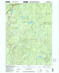
1997 Map of Skytop
USGS Topo · Published 2000About this map
The Delaware State Forest dominates this landscape in Monroe and Pike Counties, characterized by a complex network of wetlands and mountain waters. High-elevation swamps like Kintz Swamp, Panther Swamp, and Henderson Swamp feed numerous runs and creeks that carve through the plateau. This 1990s survey shows the established recreational and institutional character of the area, anchored by Skytop and its Golf Course in the northwest. To the south, specialized settlements and recreational tracts appear, including the Hiawatha Club, Easton Anglers, and youth retreats such as Camp Canadensis and Camp William Penn. The topography is defined by prominent elevations like West Mountain and Snow Hill, while the Pennel Run Natural Area preserves the wild character of the eastern forest. Local history and genealogy interest is grounded in sites like the McComas Cem near Brodhead Creek.
Find a feature on this map
60 named features on this map. Tap any name to fly to it.
Don’t see what you’re looking for? This feature index may not catch every label — zoom into the map to look around manually.
Map Details
Editions of this 1997 Skytop Map
This is the sole edition of this map. No revisions or reprints were ever made.
Other maps of this area

1919 · Pocono
USGS Topo · 1:62,500

1921 · Pocono
USGS Topo · 1:62,500

1923 · Pocono
USGS Topo · 1:62,500

1924 · Bushkill
USGS Topo · 1:48,000

1928 · Ariel
USGS Topo · 1:62,500

1932 · Ariel
USGS Topo · 1:62,500

1935 · Hawley
USGS Topo · 1:62,500

1938 · Hawley
USGS Topo · 1:62,500

1943 · Bushkill
USGS Topo · 1:62,500

1943 · Pocono
USGS Topo · 1:62,500
Featured Places
- Greene Township, PA
- Porter Township, PA
- Paradise Township, PA
- Middle Smithfield Township, PA
- Cresco, Barrett Township