
1948 Map of Slate Run
USGS Topo · Published 1948About this map
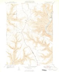
Pine Creek carves a deep valley through the high plateaus of Lycoming and Clinton counties, following a route shared by the New York Central railroad. This 1940s landscape is defined by its drainage network, where local landmarks like the Pump Station Fire Tower overlook a topography of steep hollows and runs. The small settlement of Slate Run serves as the primary hub of human activity, situated where its namesake waterway meets the larger creek gorge. Genealogists and local historians can find a local Cem near the village, while the surrounding townships of Stewardson, Brown, and McHenry are mapped with precision. The map reveals the intricate network of tributaries including Trout Run, Hyner Run, and several numbered hollows like Number Four Hollow Run, illustrating the complex water-carved geography of the Pennsylvania Wilds during the post-war era.
Find a feature on this map
41 named features on this map. Tap any name to fly to it.
Don’t see what you’re looking for? This feature index may not catch every label — zoom into the map to look around manually.
Map Details
Editions of this 1948 Slate Run Map
2 editions found
Historical Maps of Brown Township Through Time
52 maps found

1921 Trout Run
Lycoming County, PA

1923 Trout Run
Lycoming County, PA

1930 Warrensville
Lycoming County, PA

1934 Warrensville
Lycoming County, PA

1935 Waterville
Lycoming County, PA

1937 Waterville
Lycoming County, PA

1943 Waterville
Lycoming County, PA

1944 Trout Run
Lycoming County, PA

1946 Slate Run
Lycoming County, PA
1948 Slate Run
Lycoming County, PA

1953 Warrensville
Lycoming County, PA

1965 Barbours
Lycoming County, PA

1965 Bodines
Lycoming County, PA

1965 Cammal
Lycoming County, PA

1965 Cogan Station
Lycoming County, PA

1965 English Center
Lycoming County, PA

1965 Huntersville
Lycoming County, PA

1965 Jersey Mills
Lycoming County, PA

1965 Linden
Lycoming County, PA

1965 Montoursville North
Lycoming County, PA

1965 Montoursville South
Lycoming County, PA

1965 Trout Run
Lycoming County, PA

1965 Waterville
Lycoming County, PA

1965 White Pine
Lycoming County, PA

1969 Grover
Lycoming County, PA

1969 Ralston
Lycoming County, PA

1977 Ralston
Lycoming County, PA

1984 Williamsport East
Lycoming County, PA

1994 Cammal
Lycoming County, PA

1994 Cogan Station
Lycoming County, PA

1994 English Center
Lycoming County, PA

1994 Montoursville South
Lycoming County, PA

1994 Slate Run
Lycoming County, PA

1994 Waterville
Lycoming County, PA

1995 Barbours
Lycoming County, PA

1999 Montoursville North
Lycoming County, PA

2023 Barbours
Lycoming County, PA

2023 Bodines
Lycoming County, PA

2023 Cammal
Lycoming County, PA

2023 Cogan Station
Lycoming County, PA

2023 English Center
Lycoming County, PA

2023 Grover
Lycoming County, PA

2023 Huntersville
Lycoming County, PA

2023 Jersey Mills
Lycoming County, PA

2023 Linden
Lycoming County, PA

2023 Montoursville North
Lycoming County, PA

2023 Montoursville South
Lycoming County, PA

2023 Ralston
Lycoming County, PA

2023 Slate Run
Lycoming County, PA

2023 Trout Run
Lycoming County, PA

2023 Waterville
Lycoming County, PA

2023 White Pine
Lycoming County, PA
Featured Locations
- Grugan Township, PA
- Brown Township, PA
- McHenry Township, PA
- Stewardson Township, PA
- Slate Run, Brown Township