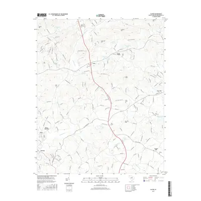
2017 Map of Slater
USGS Topo · Published 2017About this map
Lima and Cross Plains sit at the center of this 2017 survey, where the foothills of the Blue Ridge meet the upper Piedmont of Greenville County. The landscape is defined by the headwaters of the N Saluda River and N Enoree River, showing a rural character preserved even as surrounding areas developed. Numerous small family and community burial grounds, such as the Hawkins-Hightower Family Cem and Mush Creek Cem, are scattered across the terrain, offering significant points of interest for genealogists tracing local lineage.
Find a feature on this map
180 named features on this map. Tap any name to fly to it.
Don’t see what you’re looking for? This feature index may not catch every label — zoom into the map to look around manually.
Map Details
Editions of this 2017 Slater Map
This is the sole edition of this map. No revisions or reprints were ever made.
Other maps of this area

1888 · Pickens
USGS Topo · 1:125,000

1894 · Pickens
USGS Topo · 1:125,000

1905 · Pisgah
USGS Topo · 1:125,000

1906 · Pisgah
USGS Topo · 1:125,000

1907 · Saluda
USGS Topo · 1:125,000

1935 · Standingstone Mtn.
USGS Topo · 1:24,000

1935 · Greenville
USGS Topo · 1:48,000

1935 · Zirconia
USGS Topo · 1:24,000

1938 · Greenville
USGS Topo · 1:62,500
1946 · Standingstone Mtn.
USGS Topo · 1:24,000