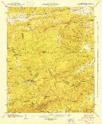
1946 Map of Standingstone Mtn.
USGS Topo · Published 1947About this map
Standingstone Mountain towers over this mid-1940s landscape, marking a significant point on the Blue Ridge Divide along the border of North Carolina and South Carolina. This era shows a region defined by its rugged topography and the early development of recreational and conservation areas. Notable landmarks include the Cleveland Fish Hatchery in the south and various camps like Reasonover Camp and Camp Greenville. The presence of several country churches, including Friendship Ch, Holly Springs Ch, and Crab Creek Ch, suggests a dispersed but connected rural community. The complex hydrology of the area is mapped in detail, featuring numerous waterfalls such as Triple Falls, High Falls, and Bridal Veil Falls along the Little River. This survey captures the terrain just as the Buck Forest area was being managed, providing a precise look at the transition between the Saluda Mountains and the northern plateau before modern development altered these watershed paths.
Find a feature on this map
104 named features on this map. Tap any name to fly to it.
Don’t see what you’re looking for? This feature index may not catch every label — zoom into the map to look around manually.
Map Details
Editions of this 1946 Standingstone Mtn. Map
3 editions found
Other maps of this area

1905 · Pisgah
USGS Topo · 1:125,000

1906 · Pisgah
USGS Topo · 1:125,000

1907 · Saluda
USGS Topo · 1:125,000

1935 · Brevard
USGS Topo · 1:24,000

1935 · Standingstone Mtn.
USGS Topo · 1:24,000

1935 · Horse Shoe
USGS Topo · 1:24,000

1935 · Hendersonville
USGS Topo · 1:24,000

1935 · Table Rock
USGS Topo · 1:24,000

1935 · Zirconia
USGS Topo · 1:24,000

1935 · Pisgah Forest
USGS Topo · 1:24,000
Featured Places
- Jeter Mountain Terrace, NC
- Greenville County, SC
- Henderson County, NC
- Transylvania County, NC
- United States