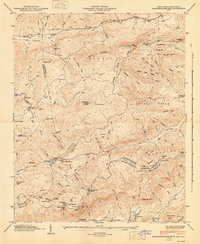
1946 Map of Standingstone Mtn.
USGS Topo · Published 1947About this map
Standingstone Mountain towers over a landscape defined by the drainage divide between the Green River and the Middle Saluda River, marking the sharp boundary between North Carolina and South Carolina. In the mid-1940s, this area of Henderson Co and Transylvania Co was a network of high-elevation camps and remote institutional landmarks. Notable features include Reasonover Camp and Camp Greenville, alongside the Cleveland Fish Hatchery near the southern border.
Find a feature on this map
97 named features on this map. Tap any name to fly to it.
Don’t see what you’re looking for? This feature index may not catch every label — zoom into the map to look around manually.
Map Details
Editions of this 1946 Standingstone Mtn. Map
3 editions found
Other maps of this area

1905 · Pisgah
USGS Topo · 1:125,000

1906 · Pisgah
USGS Topo · 1:125,000

1907 · Saluda
USGS Topo · 1:125,000

1935 · Brevard
USGS Topo · 1:24,000

1935 · Standingstone Mtn.
USGS Topo · 1:24,000

1935 · Horse Shoe
USGS Topo · 1:24,000

1935 · Hendersonville
USGS Topo · 1:24,000

1935 · Table Rock
USGS Topo · 1:24,000

1935 · Zirconia
USGS Topo · 1:24,000

1935 · Pisgah Forest
USGS Topo · 1:24,000
Featured Places
- Jeter Mountain Terrace, NC
- Greenville County, SC
- Henderson County, NC
- Transylvania County, NC
- United States