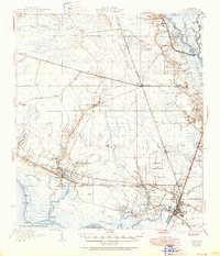
1935 Map of Slidell
USGS Topo · Published 1951About this map
Slidell and its surrounding marshlands are documented here in the early 1950s, showing a landscape defined by the intersection of the Gulf Mobile and Ohio and Southern railroads. The area transition from the piney woods of the St Tammany State Game Forest in the west to the intricate network of the Little West Pearl River in the east. Local life centers on small settlements like Lacombe, Pearl River, and Hickory, with community landmarks such as Peace Grove Ch and the Forest Glen Sch providing touchpoints for genealogical research. Along the northern shore of Lake Pontchartrain, the Bayou Lacombe LH marks the navigation entrance at Goose Pt. The mapping of the Military Reservation and family holdings like Dixie Ranch illustrates the mix of federal land use and private homesteads in St Tammany Parish during this era.
Find a feature on this map
65 named features on this map. Tap any name to fly to it.
Don’t see what you’re looking for? This feature index may not catch every label — zoom into the map to look around manually.
Map Details
Editions of this 1935 Slidell Map
3 editions found
Other maps of this area

1891 · Spanish Fort
USGS Topo · 1:62,500

1892 · Chef Menteur
USGS Topo · 1:62,500

1893 · Rigolets
USGS Topo · 1:62,500

1914 · Nicholson
USGS Topo · 1:62,500

1921 · Nicholson
USGS Topo · 1:62,500

1935 · Slidell
USGS Topo · 1:62,500

1935 · Covington
USGS Topo · 1:62,500

1936 · North Shore
USGS Topo · 1:31,680

1936 · South Point
USGS Topo · 1:31,680

1936 · Chef Menteur
USGS Topo · 1:62,500