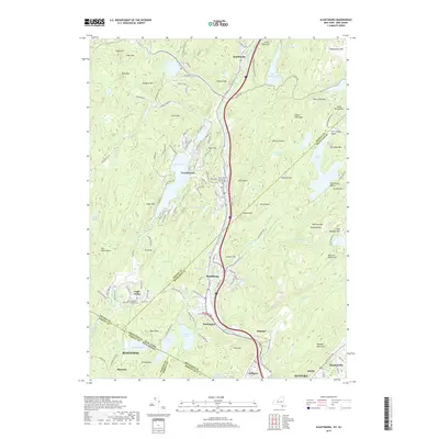
2019 Map of Sloatsburg
USGS Topo · Published 2019About this map
The Ramapo River corridor serves as the central artery for this mountainous borderland, where the Norfolk Southern railway parallels the valley's established settlements. Tuxedo Park and Sloatsburg are the primary hubs, surrounded by high peaks like Wildcat Mtn and Hogback Mtn. The map highlights a landscape defined by significant water bodies, including Tuxedo Lake and Lake Stahahe, which are nestled among the Ramapo Mountains. Local heritage is anchored by sites such as Saint Marys In Tuxedo and the Tuxedo Church Cem, while the southern reaches transition into the estate-dotted grounds of Skylands near the New Jersey state line. The intricate network of wetlands like Delaney Swamp and Spruce Swamp reflects a complex drainage system feeding into the Ringwood River.
Find a feature on this map
152 named features on this map. Tap any name to fly to it.
Don’t see what you’re looking for? This feature index may not catch every label — zoom into the map to look around manually.
Map Details
Editions of this 2019 Sloatsburg Map
This is the sole edition of this map. No revisions or reprints were ever made.
Other maps of this area

1891 · Greenwood Lake
USGS Topo · 1:62,500

1891 · Ramapo
USGS Topo · 1:62,500

1893 · Greenwood Lake
USGS Topo · 1:62,500

1893 · Ramapo
USGS Topo · 1:62,500

1902 · Schunemunk
USGS Topo · 1:62,500

1903 · Greenwood Lake
USGS Topo · 1:62,500

1906 · Goshen
USGS Topo · 1:62,500

1908 · Goshen
USGS Topo · 1:62,500

1910 · Ramapo
USGS Topo · 1:62,500

1910 · Greenwood Lake
USGS Topo · 1:62,500