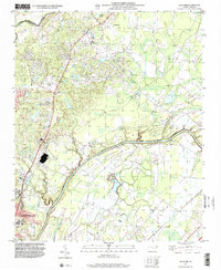
1997 Map of Slocomb
USGS Topo · Published 2000About this map
The Cape Fear River and Little River converge in this northern Cumberland County landscape, where rural communities like Slocomb and Linden sit at the intersection of agriculture and expanding infrastructure. The map reveals a transition from traditional land use toward modern development, evidenced by the presence of a Race Track, multiple unnamed landing strips, and a major pipeline corridor cutting across the terrain. Near the northern border of Fayetteville, community life is anchored by landmarks such as Long Hill Sch and the Athletic Field. Smaller settlements like Carlos and Lane are visible in the eastern reaches, while an upland Ranger Station and Tower overlook the varied topography. This 1997-derived imagery provides a clear view of the area before significant turn-of-the-century suburbanization altered these riverfront corridors.
Find a feature on this map
19 named features on this map. Tap any name to fly to it.
Don’t see what you’re looking for? This feature index may not catch every label — zoom into the map to look around manually.
Map Details
Editions of this 1997 Slocomb Map
This is the sole edition of this map. No revisions or reprints were ever made.
Other maps of this area

1948 · Fayetteville
USGS Topo · 1:62,500

1948 · Slocomb
USGS Topo · 1:24,000

1949 · Vander
USGS Topo · 1:24,000

1950 · Fayetteville
USGS Topo · 1:24,000

1950 · Manchester
USGS Topo · 1:24,000

1950 · Slocomb
USGS Topo · 1:24,000

1953 · Raleigh
USGS Topo · 1:250,000

1954 · Raleigh
USGS Topo · 1:250,000

1956 · Anderson Creek
USGS Topo · 1:24,000

1956 · Bunnlevel
USGS Topo · 1:24,000