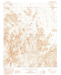
1990 Map of Slumgullion Pass
USGS Topo · Published 1990About this map
The Castle Dome Mountains dominate this arid landscape within the Kofa National Wildlife Refuge in Yuma County. This provisional 1990 survey, based on data collected across several decades, reveals a high concentration of mineral exploration and water management in a desert environment. Prospectors and miners were active at the Big Eye Mine and the Keystone Mine, while several unnamed Mine Shaft and Prospects labels indicate widespread extraction efforts.
Find a feature on this map
25 named features on this map. Tap any name to fly to it.
Don’t see what you’re looking for? This feature index may not catch every label — zoom into the map to look around manually.
Map Details
Editions of this 1990 Slumgullion Pass Map
This is the sole edition of this map. No revisions or reprints were ever made.
Other maps of this area

1928 · Norton
USGS Topo · 1:62,500

1929 · Norton
USGS Topo · 1:62,500

1942 · Yuma
USGS Topo · 1:250,000

1942 · Blythe
USGS Topo · 1:250,000

1942 · Vicksburg
USGS Topo · 1:250,000

1953 · Ajo
USGS Topo · 1:250,000

1954 · El Centro
USGS Topo · 1:250,000

1954 · Salton Sea
USGS Topo · 1:250,000

1954 · Phoenix
USGS Topo · 1:250,000

1955 · Salton Sea
USGS Topo · 1:250,000