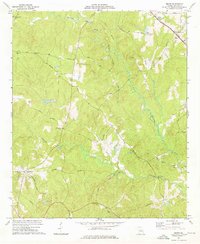
1974 Map of Smarr
USGS Topo · Published 1976About this map
Smarr and Russellville serve as the primary focal points in this central Georgia landscape, which is defined by a dense network of country roads and small community churches. The Central of Georgia railroad cuts through the northeastern corner near Smarr, while historical thoroughfares like Old Zebulon Road and Maynard Mill Road reveal the area's established rural connections. The terrain is deeply carved by the waters of Tobesofkee Creek and its many tributaries, including Rock Branch and Yellow Creek.
Find a feature on this map
33 named features on this map. Tap any name to fly to it.
Don’t see what you’re looking for? This feature index may not catch every label — zoom into the map to look around manually.
Map Details
Editions of this 1974 Smarr Map
This is the sole edition of this map. No revisions or reprints were ever made.
Other maps of this area

1951 · Yatesville
USGS Topo · 1:62,500

1951 · Forsyth
USGS Topo · 1:62,500

1951 · Barnesville
USGS Topo · 1:62,500

1953 · Atlanta
USGS Topo · 1:250,000

1953 · Athens
USGS Topo · 1:250,000

1955 · Phenix City
USGS Topo · 1:250,000

1956 · Bolingbroke
USGS Topo · 1:62,500

1957 · Phenix City
USGS Topo · 1:250,000

1957 · Macon
USGS Topo · 1:250,000

1957 · Atlanta
USGS Topo · 1:250,000