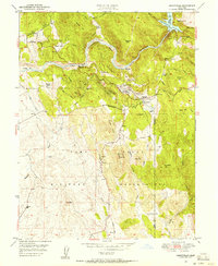
1949 Map of Smartville
USGS Topo · Published 1956About this map
The Yuba River carves a winding path through this Gold Country landscape, dominated by the massive acreage of the Camp Beale Military Reservation in the southern half. The terrain is marked by the legacy of hydraulic mining, with numerous "flats" and "bars" indicating historical activity, including Sicard Flat, Sucker Flat, and the site of Parks Bar. Evidence of this industry remains visible through the sprawling Tailings fields and the Blue Point Mine near Smartville.
Find a feature on this map
62 named features on this map. Tap any name to fly to it.
Don’t see what you’re looking for? This feature index may not catch every label — zoom into the map to look around manually.
Map Details
Editions of this 1949 Smartville Map
This is the sole edition of this map. No revisions or reprints were ever made.
Other maps of this area

1888 · Smartsville
USGS Topo · 1:125,000

1891 · Smartsville
USGS Topo · 1:125,000

1892 · Smartsville
USGS Topo · 1:125,000

1894 · Smartsville
USGS Topo · 1:125,000

1895 · Smartsville
USGS Topo · 1:125,000

1910 · Wheatland
USGS Topo · 1:31,680

1911 · Browns Valley
USGS Topo · 1:31,680
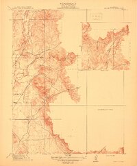
1912 · Prairie Creek
USGS Topo · 1:31,680

1915 · Spenceville
USGS Topo · 1:31,680

1941 · Bangor
USGS Topo · 1:62,500