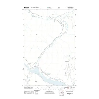
2011 Map of Smeads Bench
USGS Topo · Published 2011About this map
Cabinet Gorge Reservoir dominates the southern landscape of this 2011 survey, where the Bull River flows into the impounded waters of the Clark Fork. This area of Sanders County is defined by steep drainage corridors and narrow mountain roads like Old Bull River Rd and Little Bear Rd. The settlement pattern is largely recreational and service-oriented, centered near the Noxon Siding and Smeads Bench areas. Local infrastructure such as the Noxon Satellite Fire Dept and seasonal stops like the Hereford Restaurant Campground reflect the modern utility of the valley. To the north, the terrain rises sharply toward Government Mountain and Pilik Ridge, cut by numerous named ravines including Napoleon Gulch, Copper Gulch, and Gin Gulch. The transport network follows the water, with Railroad Rd skirting the southern shore of the reservoir.
Find a feature on this map
32 named features on this map. Tap any name to fly to it.
Don’t see what you’re looking for? This feature index may not catch every label — zoom into the map to look around manually.
Map Details
Editions of this 2011 Smeads Bench Map
This is the sole edition of this map. No revisions or reprints were ever made.
Other maps of this area

1920 · Libby
USGS Topo · 1:125,000

1930 · Libby
USGS Topo · 1:125,000

1932 · Libby
USGS Topo · 1:125,000

1932 · Trout Creek
USGS Topo · 1:125,000

1935 · Trout Creek
USGS Topo · 1:125,000

1936 · Trout Creek
USGS Topo · 1:125,000

1956 · Wallace
USGS Topo · 1:250,000

1957 · Kalispell
USGS Topo · 1:250,000

1960 · Kalispell
USGS Topo · 1:250,000

1960 · Wallace
USGS Topo · 1:250,000