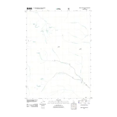
2011 Map of Smiley Mountain
USGS Topo · Published 2011About this map
Smiley Mountain dominates this high-elevation landscape, where a dense cluster of mountain lakes defines the geography. In the northwest, Golden Lake, Big Lake, and Rough Lake are interconnected by Lake Creek, while Iron Bog Lake and Fishpole Lake sit at the headwaters of the Left Fork Iron Bog Creek to the south. The drainage patterns on this map are particularly intricate, with the Right Fork Bear Creek and Middle Fork Bear Creek flowing east, while Smiley Creek originates near Smiley Meadows. This 2011 survey records the road network as it existed in the early 21st century, showing routes winding through Big Canyon and Hurst Canyon along the eastern edge of the quadrangle. The map captures an unpopulated wilderness area of Blaine County, focusing entirely on natural features and water systems.
Find a feature on this map
23 named features on this map. Tap any name to fly to it.
Don’t see what you’re looking for? This feature index may not catch every label — zoom into the map to look around manually.
Map Details
Editions of this 2011 Smiley Mountain Map
This is the sole edition of this map. No revisions or reprints were ever made.
Other maps of this area

1935 · MacKay
USGS Topo · 1:96,000

1940 · Mackay
USGS Topo · 1:62,500

1955 · Idaho Falls
USGS Topo · 1:250,000

1958 · Idaho Falls
USGS Topo · 1:250,000

1960 · Muldoon Canyon
USGS Topo · 1:62,500

1960 · Grouse
USGS Topo · 1:62,500

1960 · Mackay
USGS Topo · 1:62,500

1960 · Copper Basin
USGS Topo · 1:62,500
1988 · Arco
USGS Topo · 1:100,000
1991 · Trail Creek
USGS Topo · 1:24,000