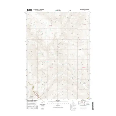
2013 Map of Smiley Mountain
USGS Topo · Published 2013About this map
High mountain peaks and a dense network of glacial alpine lakes define this portion of the Challis National Forest and Sawtooth National Forest. Centered on the 11,508-foot peak of Smiley Mtn, the map reveals a landscape shaped by ice, where dozens of small water bodies like Golden Lake, Rough Lake, Long Lake, and Round Lake occupy high-elevation basins. These remote watersheds feed the Right Fork Iron Bog Cr and Left Fork Iron Bog Cr, which join to flow toward the southwest. The boundary between Blaine Co and Custer Co follows the jagged ridgeline near Pioneer Mtn, marking a significant natural divide in the high backcountry. Below the peaks, Smiley Meadows and the surrounding canyons like Muldoon Canyon and Anderson Canyon provide the only level breaks in this steep, high-altitude terrain.
Find a feature on this map
35 named features on this map. Tap any name to fly to it.
Don’t see what you’re looking for? This feature index may not catch every label — zoom into the map to look around manually.
Map Details
Editions of this 2013 Smiley Mountain Map
This is the sole edition of this map. No revisions or reprints were ever made.
Other maps of this area

1935 · MacKay
USGS Topo · 1:96,000

1940 · Mackay
USGS Topo · 1:62,500

1955 · Idaho Falls
USGS Topo · 1:250,000

1958 · Idaho Falls
USGS Topo · 1:250,000

1960 · Muldoon Canyon
USGS Topo · 1:62,500

1960 · Grouse
USGS Topo · 1:62,500

1960 · Mackay
USGS Topo · 1:62,500

1960 · Copper Basin
USGS Topo · 1:62,500
1988 · Arco
USGS Topo · 1:100,000
1991 · Trail Creek
USGS Topo · 1:24,000