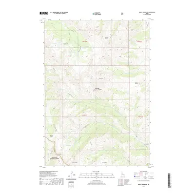
2020 Map of Smiley Mountain
USGS Topo · Published 2020About this map
Smiley Mtn serves as a central landmark in this high-elevation landscape where the Challis National Forest meets the Sawtooth National Forest. The map documents a complex network of alpine water bodies and drainage systems, including the headwaters of Smiley Cr and the Right Fork Iron Bog Cr. A series of interconnected basins contain notable features like Big Lake, Golden Lake, and Fishpole Lake, while deep geographic cuts such as Muldoon Canyon and Anderson Canyon define the area's sharp vertical relief. The presence of the Muldoon-Ironbog Trail and the Brockie Lake Trail suggests a long-standing system of back-country access through the passes near Pioneer Mtn, marking a terrain defined more by its natural water distribution and steep canyons than by any permanent human settlements.
Find a feature on this map
47 named features on this map. Tap any name to fly to it.
Don’t see what you’re looking for? This feature index may not catch every label — zoom into the map to look around manually.
Map Details
Editions of this 2020 Smiley Mountain Map
This is the sole edition of this map. No revisions or reprints were ever made.
Other maps of this area

1935 · MacKay
USGS Topo · 1:96,000

1940 · Mackay
USGS Topo · 1:62,500

1955 · Idaho Falls
USGS Topo · 1:250,000

1958 · Idaho Falls
USGS Topo · 1:250,000

1960 · Muldoon Canyon
USGS Topo · 1:62,500

1960 · Grouse
USGS Topo · 1:62,500

1960 · Mackay
USGS Topo · 1:62,500

1960 · Copper Basin
USGS Topo · 1:62,500
1988 · Arco
USGS Topo · 1:100,000
1991 · Trail Creek
USGS Topo · 1:24,000