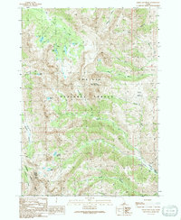
1991 Map of Smiley Mountain
USGS Topo · Published 1991About this map
Smiley Mountain dominates this high-altitude landscape along the border of Blaine and Custer counties. The area is defined by a dense concentration of glacial cirque lakes, including Golden Lake, Big Lake, Rough Lake, and Long Lake tucked beneath the northern ridges, while Fishpole Lake and Iron Bog Lake sit further south. This high wilderness environment, shared by the Challis National Forest and Sawtooth National Forest, shows evidence of intermittent human activity through several prospect sites and an adit located near Iron Bog Creek.
Find a feature on this map
36 named features on this map. Tap any name to fly to it.
Don’t see what you’re looking for? This feature index may not catch every label — zoom into the map to look around manually.
Map Details
Editions of this 1991 Smiley Mountain Map
This is the sole edition of this map. No revisions or reprints were ever made.
Other maps of this area

1935 · MacKay
USGS Topo · 1:96,000

1940 · Mackay
USGS Topo · 1:62,500

1955 · Idaho Falls
USGS Topo · 1:250,000

1958 · Idaho Falls
USGS Topo · 1:250,000

1960 · Muldoon Canyon
USGS Topo · 1:62,500

1960 · Grouse
USGS Topo · 1:62,500

1960 · Mackay
USGS Topo · 1:62,500

1960 · Copper Basin
USGS Topo · 1:62,500
1988 · Arco
USGS Topo · 1:100,000
1991 · Trail Creek
USGS Topo · 1:24,000